AI4Climate Seminar: High-resolution canopy height and wood volume maps in France based on satellite remote sensing with a deep learning approach – Martin Schwartz, 27th of March 11:00 CET at Kayrros

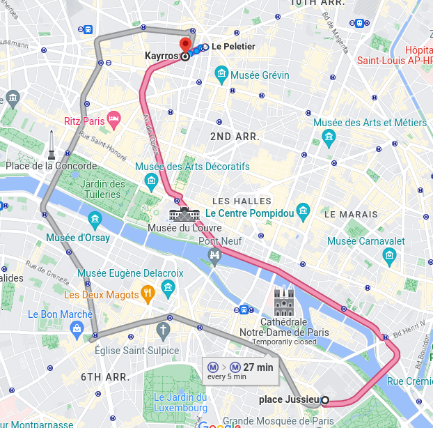
The seminar is on March the 27th, at 11:00 (CET) remotely and in person. The in-person meeting will be held in the Kayrros conference room, in Paris (map at the end of the post).

If you like to attend online, the link for the zoom is here: https://zoom.us/j/95758673139?pwd=blg3ZlhqVWw3Tk5EYUU0OEI3K3lvUT09

Short Abstract: In European forests that are divided into stands of small size and may show heterogeneity within stands, a high spatial resolution (10 – 20 meters) is arguably needed to capture the differences in canopy height. In this work, we developed a deep learning U-Net model based on multi-stream remote sensing measurements to create a high-resolution canopy height map of France. Our model uses multi-band images from Sentinel-1 and Sentinel-2 with composite time averages as input to predict tree height derived from GEDI waveforms. Thanks to forest inventory plots, we then turned this height map into a 10 m resolution wood volume map that we used to carry out wood volume estimations in different french regions. This works paves the way to a monitoring of biomass at high resolution and could bring key information for forest management policies.

BioMartin Schwartz is a young researcher who graduated from Ecole Polytechnique in 2020. During his gap year, he worked at Carbone 4, a leading consulting firm specializing in climate change and sustainability. Currently, Martin is in his 3rd year of PhD, supervised by Philippe Ciais and Catherine Ottlé at the Laboratory for Climate Science and Environment (LSCE). His research is focused on remote sensing and deep learning techniques applied to GEDI data, with the aim of advancing our understanding of forest canopy height and forest biomass at fine scale. His work has been done in collaboration with Kayrros which helped in the development of his research.

Kayrros: Kayrros is a French company that leverages advanced technologies like AI and satellite imagery to provide real-time insights and forecasting for the energy and commodity markets, with a focus on sustainability and environmental issues. They offer data-driven solutions for emissions, deforestation, and other environmental risks, helping businesses and governments make informed and sustainable decisions.

Location: Kayrros offices, Rue La Fayette, 75009 Paris. It is 18 minutes from Jussieu by metro.

Eddy Detecting Neural Networks: harnessing visible satellite imagery and altimetry for operational oceanography – Evangelos Moschos

Our next seminar will be held on Wednesday the 11th of May 2022, at 14h00 ECT, at the Pierre et Marie Curie campus of Sorbonne Université, in seminar room 105 of LiP6, located on the first floor of the corridor 25/26 (easier access through tower 26).


The seminar can also be followed remotely through zoom here: https://zoom.us/j/98859268451 

You can ask questions during and after the talk in the slack channel: https://tinyurl.com/AI4CLIMATESLACK


Evangelos Moschos’ talk is entitled:

« Eddy Detecting Neural Networks: harnessing visible satellite imagery and altimetry for operational oceanography »

Mesoscale Eddies are oceanic vortices with a typical radius of the order of 20–80 km. They live for days, months or even years, trapping and transporting heat, salt, pollutants, and various biogeochemical components from their regions of formation to remote areas. Eddies have a primordial role in the oceanic circulation modifying the surface currents as well as the mixed layer depth of the ocean. Thus, eddy detection and tracking is an emergent thematic of operational oceanography with advances in the last 10 years.

Eddies can be tracked on altimetry-derrived Sea Surface Height (SSH) and geostrophic velocity currents through standard detection methods. However the strong spatio-temporal interpolation of the altimetric observations raises uncertainty of detection. Satellite imagery, on the visible and infrared spectrum, contains signatures of eddies, which despite their fine-scale resolution are too complex to be processed by geometric based methods.

Machine Learning/Computer Vision methods have proved very prominent in exploiting complex remote sensing information, such as the eddy signatures on satellite imagery. We build a Convolutional Neural Network which can accurately detect the position, shape and form of mesoscale eddies in satellite Sea Surface Temperature (SST) images. Our CNN only misses 3% of coherent structures, with more than 20km radius and a clear signature on the Sea Surface Temperature, compared with a 34% miss rate of standard eddy detection methods on altimetric maps. Additionally, while standard altimetric detection has a 10% false positive rate (“ghost eddies”) the neural network detects less than 1% of ghosts.

By combining detections on data stemming from different sensors (here SSH & SST) we do also provide a set of reference nowcast (real-time) detections with almost zero uncertainty. We focus here on an application of validation of operational numerical oceanographic models in the Mediterranean Sea through the comparison of their outputs with the reference detections, allowing to quantify their nowcast error and pick-and-choose between different numerical on a certain region.

Biographic notice:
Evangelos Moschos is a PhD student at the Laboratoire de Météorologie Dynamique, Ecole Polytechnique, France. After an engineering diploma in the Athens Polytechnic, he developed a keen interest in bridging computer vision methods with earth observation and operational oceanography. Co-founder of Amphitrite, a start-up harnessing AI to provide maritime stakeholders with real-time, reliable oceanic data.